
Certified UAV Drone Services
Data Analysis & Media Group
UAV Forensics - Thermal Imaging - Cinematography - Aerial Mapping - Real Estate
Fully Insured, Multiple FAA Clearances - New York City Wide Area Blanket - Class Bravo and Night Waiver
Certified Insured UAV Drone Services from cinematography to engineering, architecture, forensic inspections, surveying, mapping training and more. Upperairvision Upperaerialvision
New Jersey - New York - Pennsylvania - Connecticut - Florida


Facade Inspections
Engineering
Architecture
Antenna Tower Inspections
FAA Night Waiver Approved
Chimney Tower
UAV Inspections
Generation Station
Power Plant
Cooling Towers
UAV Inspections
Railroads
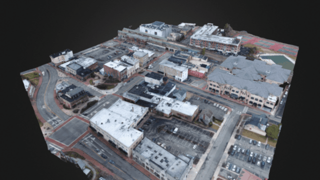
3D Accurate Aerial Photogrammetry
UAV Drone Topographical Mapping
Phillipsburg, New Jersey
Certifications

Photogrammetry Aerial 3D and Mapping
Capture all the data you need for 3D and mapping. Images and Ground Control Points.
Service Description
UAV flight are perfect for Photogrammetry and 3D imaging. Data can be used to measure stockpiles, track changes over time, measure points that are centimeter accurate, Create contour maps and export data to CAD for accurate drawings and 3d prints. Ask about our processing and rendering service. Were highly experienced with point cloud data development and processing.
Contact Details
+ 7329087309
info@UpperAerialVision.com
49 Rose Street, Phillipsburg, NJ, USA