
Certified UAV Drone Services
Data Analysis & Media Group
UAV Forensics - Thermal Imaging - Cinematography - Aerial Mapping - Real Estate
Fully Insured, Multiple FAA Clearances - New York City Wide Area Blanket - Class Bravo and Night Waiver
Certified Insured UAV Drone Services from cinematography to engineering, architecture, forensic inspections, surveying, mapping training and more. Upperairvision Upperaerialvision
New Jersey - New York - Pennsylvania - Connecticut - Florida


Facade Inspections
Engineering
Architecture
Antenna Tower Inspections
FAA Night Waiver Approved
Chimney Tower
UAV Inspections
Generation Station
Power Plant
Cooling Towers
UAV Inspections
Railroads
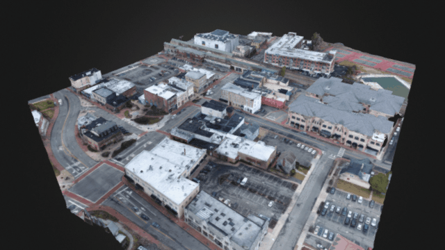
3D Accurate Aerial Photogrammetry
UAV Drone Topographical Mapping
Phillipsburg, New Jersey
Certifications

 Read More
Capture all the data you need for 3D and mapping. Images and Ground Control Points.
8 hr
1,500 US dollars
2 hr
450 US dollars
1 hr
375 US dollars Read More
Extreme high end photo video up to 6K Raw DNG Video with Zenmuse X7.
1 hr
250 US dollars Read More
Best choice for High Quality Imaging, Aerial mapping and tight spaces.
1 hr
200 US dollars Read More
Refined photogrammetry when done correctly can yield centimeter accurate point clouds.
4 hr
500 US dollars Read More
Powerpoint image report with enhanced photos and informative description of data.
4 hr
400 US dollars Read More
Add transitions, color grading, cropping and exporting to point clouds or any format.
1 hr
100 US dollars 700 US dollars
 Read More
Commercial UAV Flight training. Insurance, Flight and Data deliverables.
1,500 US dollars